
State of Nature Module
Overview
What does the State of Nature Module enable you to do?
Nala’s State of Nature Module lets you map your site locations, enabling you to locate where your interface with nature, understand the condition of the local nature and identify hotspots.
Why is Nala’s State of Nature Module important?
Your business interacts with nature at the local level. An assessment of the State of Nature around your sites is thus the foundation of meaningful corporate nature management.
The State of Nature assessment forms an integral part for corporate nature and biodiversity analyses as proposed by frameworks like the Taskforce for Nature-related Financial Disclosures (TNFD) and Science Based Target Network (SBTN) and as required by reporting regulations like the EU’s Corporate Sustainability Reporting Directive (CSRD).
How does Nala’s State of Nature Module work?
Nala’s science-based and transparent nature intelligence translates raw nature data into actionable indicators across land, water, and biodiversity.
The selection of the 14 nature indicators is based on extensive research on the data requirements for analyses under CSRD, TNFD and SBTN and the identification of the best available data sets that cover these requirements, have global coverage and are science-based and peer-reviewed.
The State of Nature Dashboard
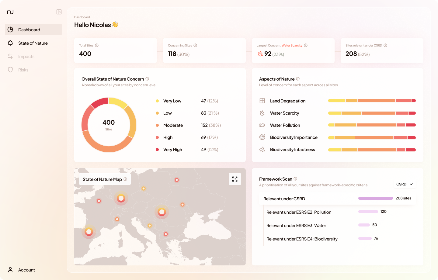
The dashboard page provides an overview over the State of Nature across all assessed sites. In this section, we'll go over the main components of the dashboard.
Overall State of Nature Concern
The Overall State of Nature Concern reflects the condition of nature around company sites, based on a comprehensive set of underlying nature indicators. For this, the concern levels of each site’s five Aspects of Nature are aggregated into an Overall State of Nature Concern Level ranging from Very Low to Very High. The donut chart illustrates how the assessed sites are distributed across the different concern levels.
If you'd like to know more about how the overall State of Nature Concern Level is Calculated, we have an explainer article here.
Aspects of Nature
All nature indicators are grouped into Aspects of Nature along the dimensions of land, water and biodiversity. For each site, the concern level associated with an Aspect of Nature is based on the highest concern level or score of all underlying indicators available for the site. The bar chart shows how the total number of assessed sites is distributed across the concern levels for each aspect of nature.
State of Nature Map
The State of Nature Map displays your sites geographically. You can expand, navigate and zoom in to the map to get a sense where on the world you interact with nature.
Framework Scan
The Framework Scan identifies sites and data points that are relevant for analysis and disclosure, based on framework-specific criteria related to the state of nature at each site. In the current version the framework scan covers the Corporate Sustainability Reporting Directive (CSRD) and the Taskforce for Nature-related Financial Disclosure (TNFD).
For further details on how the Framework Scan relates to the exact specifications of each framework, check out our detailed methodology articles here (CSRD) and here (TNFD).
The State of Nature List View
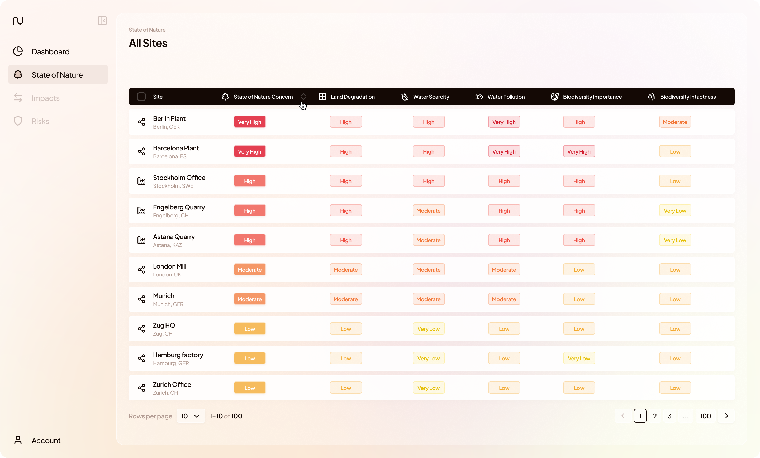
The State of Nature page “Site List” provides a list of all assessed sites, summarizing for each site the overall concern level as well as the concern level for each aspect of nature. You can navigate to the individual site view by selecting a row.
The State of Nature Site View
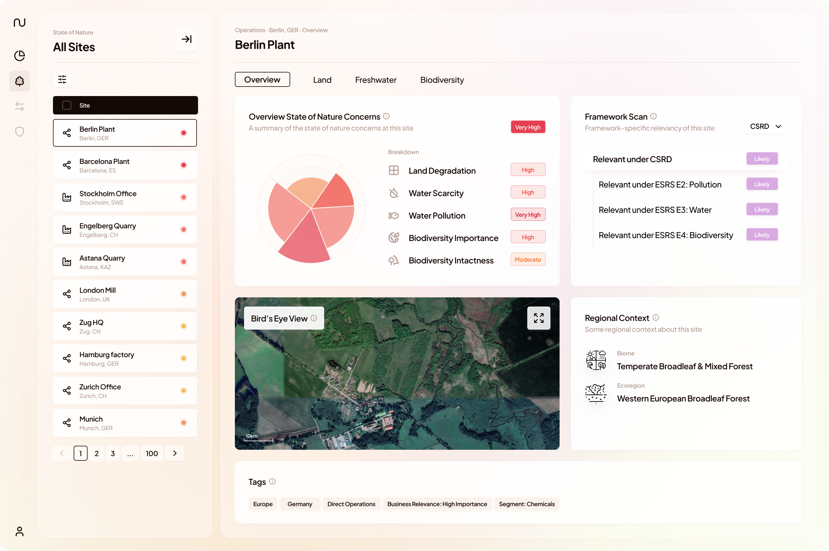
The State of Nature site-specific page provides all state of nature information available for a given site. The Overview page summarizes the state of nature assessment:
- The Overview State of Nature Concerns summarizes concerns related to the condition of the nature around the site.
- The Framework Scan flags if a site is likely to be relevant for analysis and disclosure based on framework-specific criteria on the state of nature around the site.
- The Regional Context provides information on the biome, ecoregion and river basin where the site is situated.
- The Bird's Eye View shows a high resolution satellite image of the site for context.
- The Tags are customizable labels that can be used to describe and categorize sites. You can filter by tags using the filter panel on the right.
The remaining site-specific pages Land, Freshwater, Biodiversity lead through the analysis of the all nature indicators available for the given site.
For detailed information on each indicator, check out our article on State of Nature Indicators.