
Site Management
What is the Site Management Module?
The Site Management module allows you to update and edit the input information for any of your sites in Nala’s platform, in order to enrich the analysis returned by Nala's Nature Analytics. It enables you to:
- Edit basic information about a site in the platform, such as its name, coordinates, address, etc.;
- Update and add tags
- Add or edit a site boundary polygon, resulting in more tailored State of Nature analytics for the specified area instead of a set radius around a point coordinate;
Adding details like site boundaries ensures that Nala's Nature Analytics modules return more tailored and relevant information for your sites.
In the following sections, we will outline how to use the Site Management module to make Nala’s analysis even more tailored to your needs.
Site Management Overview
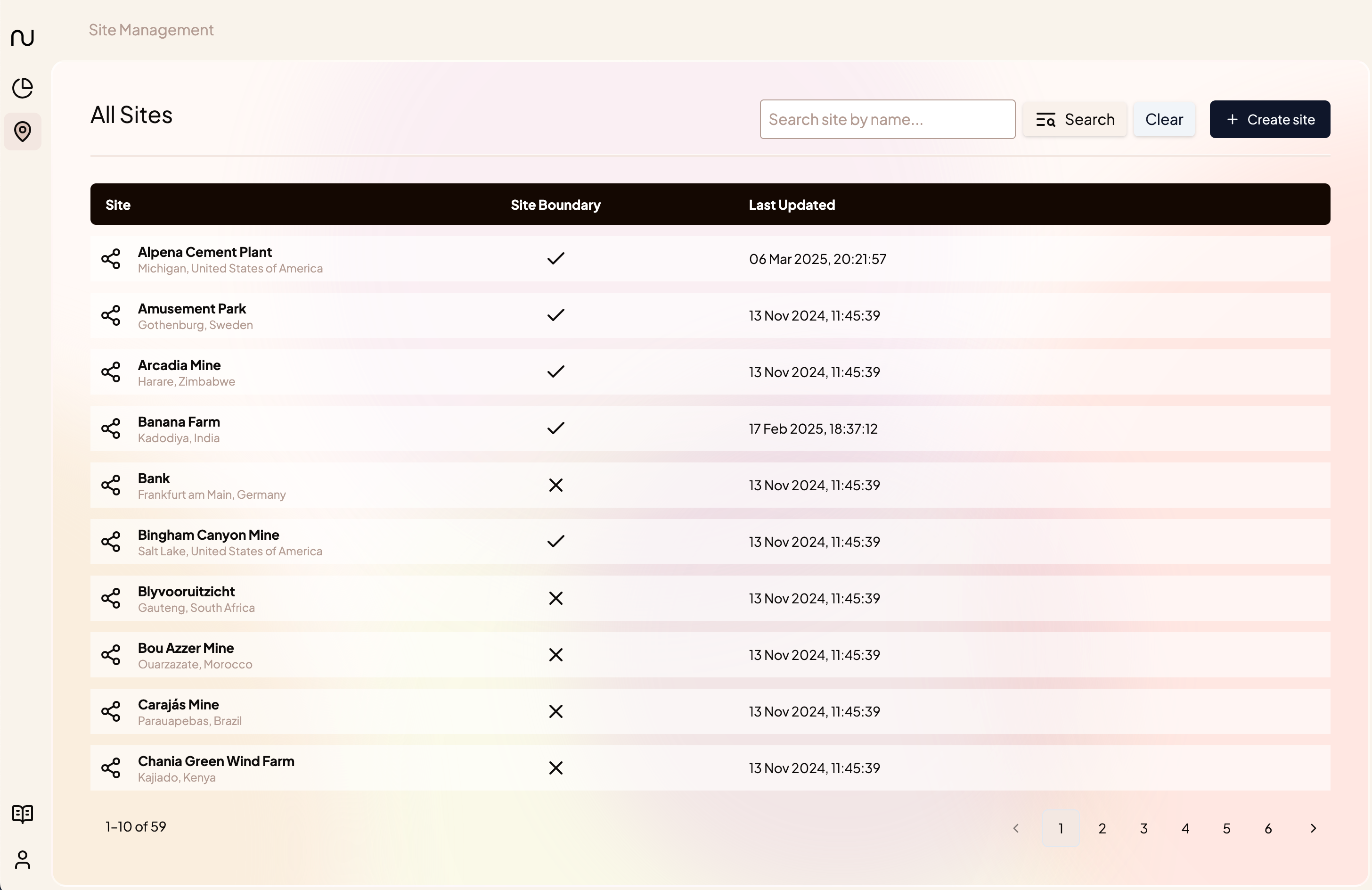
The Site Management Overview can be accessed by clicking on “Sites” in the left toolbar. Here, you can see a list of all of your sites, as well as whether a site boundary has been added and when the site information was last updated.
Click on a site’s name to view more information for that site or to update its details.
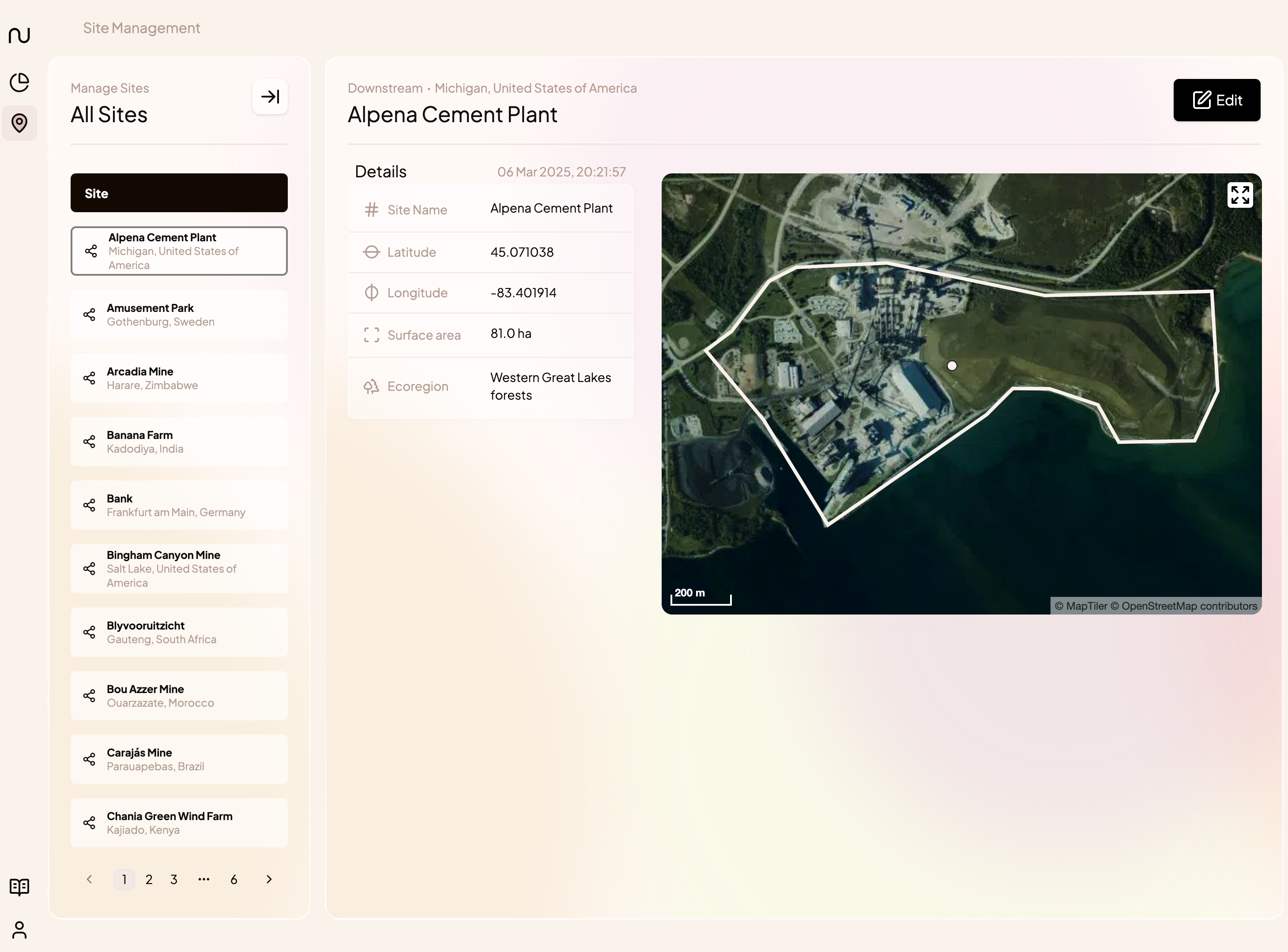
Site Overview
The site overview lists the input information Nala needs to perform Nature Analytics. If only a point location has been supplied for the site, the map will show the area around the point.
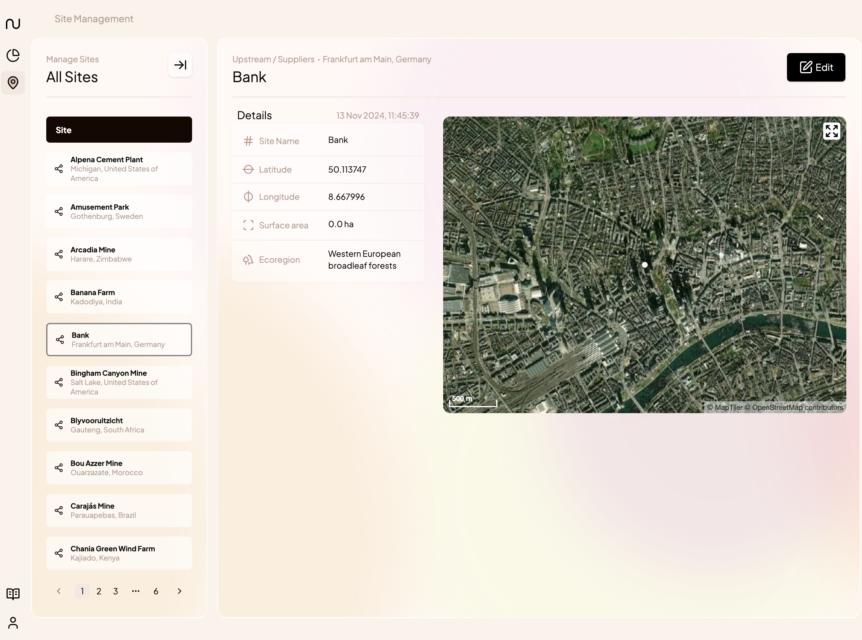
How to update a site’s details (e.g. name or coordinates)
From the site overview, click on Edit in the top right corner of the screen. In the Details tab on the following screen, you will be able to edit the site’s details, including
- name
- location details such as coordinates, address, region, country
- value chain type
- business activities
- tags
- etc
Make sure to hit Save Changes to apply your edits to the portfolio.
Note: If a site boundary polygon has been defined already, it is no longer possible to edit the coordinate, as it has been made redundant by the site boundary polygon.
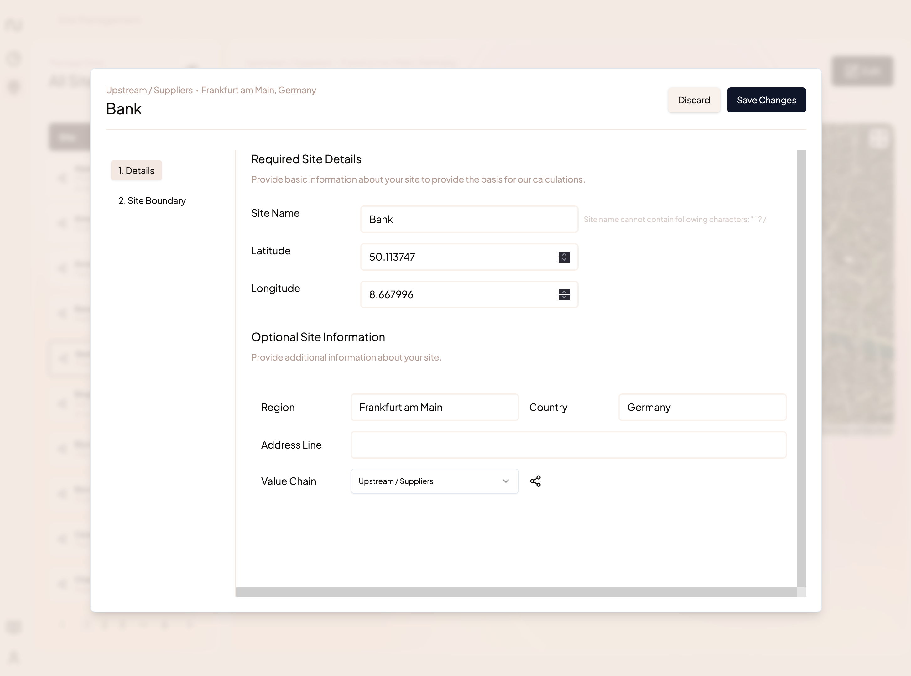
Editing a site’s name and further details in the Site Management Module
How to add a site boundary
Within the edit view, navigate to the Site Boundary Tab on the left:
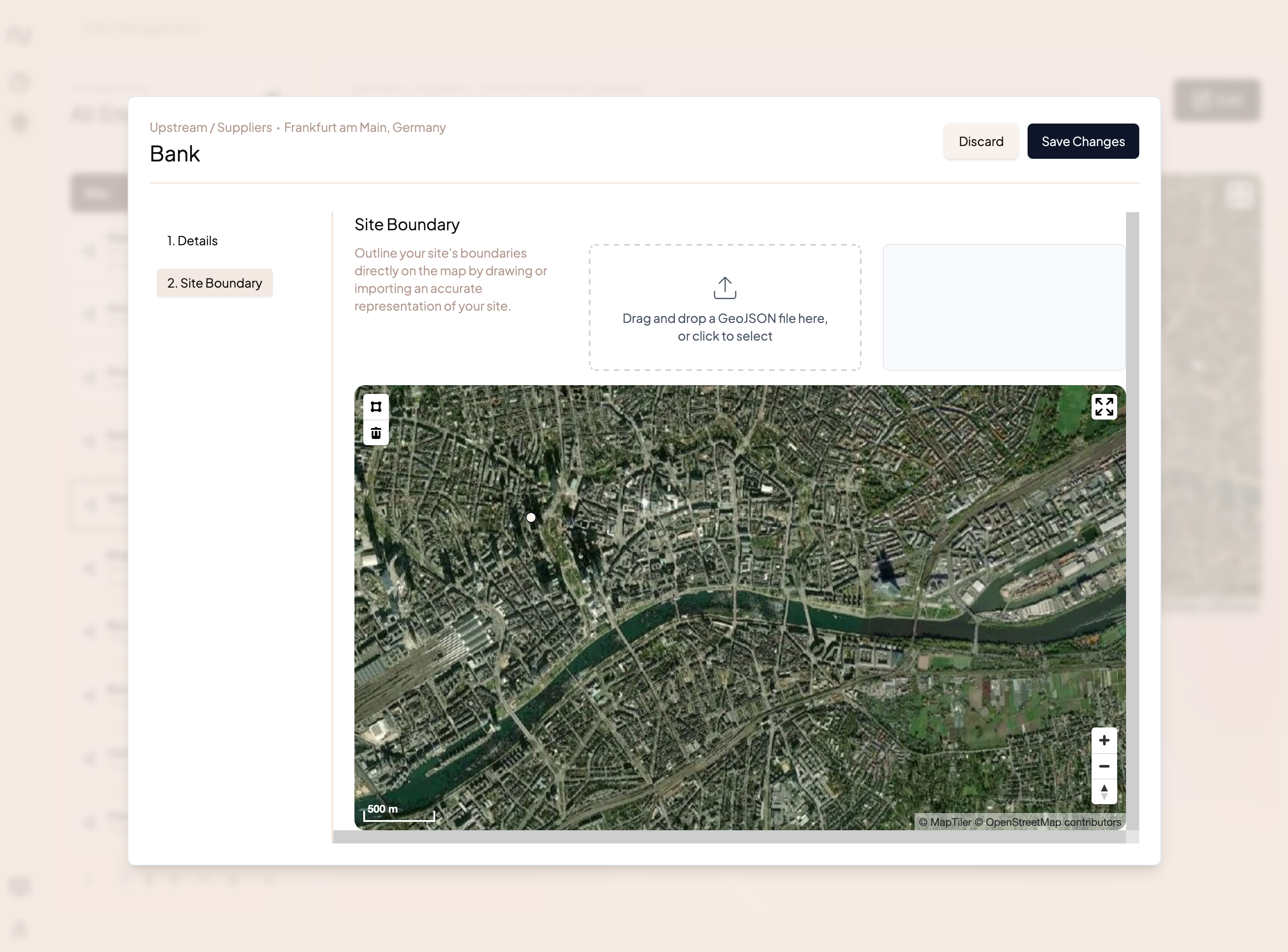
From here, you can add a site boundary in one of two ways:
- Upload a vector GIS file from your computer. Nala’s platform currently accepts polygon files in geojson format. If you have vector GIS files in a different format (e.g. shapefile, KML), please convert these to geojson format using a tool such as mapshaper.org or your favourite GIS program.
- If you don’t yet have a GIS file, you can draw a shape on the map:
- Select the square icon on in the top left corner of the map to start drawing.
- Draw your site’s boundary by clicking along the boundary on the map.
- When you have finished drawing your shape, click the first point you drew to exit the drawing mode for that shape.
- You can add more than one shape per site if you need to: simply click on another part of the map to start drawing again.
- If you need to change your shape, click again on the polygon to move the vertices around.
When you have finished uploading or drawing your site boundary, make sure to click Save Changes to save your polygon
Note: once you have specified a new site boundary, it may take a moment for the Nature Analytics to be updated for that site. If your site takes more than a few minutes to update, let us know!
Once a boundary has been added for a site, it will be shown on the map in the Site Overview.
How to add multiple sites to your portfolio at once
- Navigate to the bulk upload functionality. You can find the bulk upload in two places:
- In the Site Management module → Create Site → Multiple Sites
- The plus sign in the left hand navigation bar → Multiple Sites
- Download the template. Once you enter the flow, you will see an upload screen. Here, you can download the latest data template into which you can enter your sites’ information. We recommend always downloading the template - using an older version may result in unexpected errors when uploading the sites.
How to fill in the template
To upload your sites, Nala only needs a name, location, and value chain position - all other fields are optional. All fields can also be edited later, so don't worry if you make a mistake.
Required fields
- Site Name: Enter a unique site name.
- Latitude & Longitude: enter the site's location in decimal degrees. Please don't use other degree formats. Tip: use tools like Google Maps or EPSGI.io to find a location's coordinates. In google maps, searching for a location and right clicking on it will show its coordinates. In EPSG.io/map you can move the map to the correct location and copy the coordinates from the top of the screen.
- Country: please use the dropdown to select the country your location is in. We need the country to be formatted according to the dropdown to process it correctly.
Optional Fields
- City / Region: name of the city or region that your location is in Country: please use the dropdown to select the country your location is in. We need the country to be formatted according to the dropdown to process it correctly.
- Address
- Tags: Tags can be used to filter your portfolio by properties that are important to you, such as 'Product Type' or “Division”. Please enter a tag category name in the column header, and assign values in the columns. You can always add and edit tags later.
- Activities: Enter business activities associated with each site, using the ISIC classification. These are used to calculate the site's impacts and dependencies. You can add activities later as well.
- Upload your site file. Once you’ve filled in the template with your sites’ information, drag and drop it into the upload box.
- [Optional] Add polygons. If you’d like your sites to be uploaded with custom polygons, check the “include polygons” box. To upload polygons with your sites:
- Please upload a single zip folder containing all polygon files.
- Each site must be associated with a unique polygon file containing just that site's polygon(s). We can accept sites with a multipolygon geometry.
- We use file names to match sites to polygons, so each site's polygon file name must match the name in the "Polygon File" column in the site template, including the file extension. Example: for the file
amusement_park.geojson, please enteramusement_park.geojsonin the site list. - File Formats: Ideally, files are in GeoJSON (Point, Polygon, or MultiPolygon) format and projected in WGS84 (EPSG:4326). We can also process files in other file formats (shapefile, KML) and projections, as long as they can be converted to EPSG:4326 and GeoJSON using GDAL.
- Click Next. The flow will confirm the number of sites and polygons that were found in the upload. If you think there should be a different number of sites or polygons, go back and make sure the site information was entered correctly.
- If you’re happy to proceed, click Next
- The upload flow will now check for duplicate site names and missing required information, and flag any sites that need revision. If no issues were found, the sites will be uploaded and the process will exit with success.
All done! Your sites will now be uploaded and the platform will start calculating nature analytics. The calculation may take a few minutes, especially if you’re uploading a lot of sites at once.
Troubleshooting
The flow says my sites have been uploaded, but I can’t see them. What’s up?
It may take a few minutes for all the sites to be uploaded and the nature analytics to be available for them. Sites should appear once they are ready, but if you are missing any after 15 minutes, please let us know and we can take a look.
Why did my sites not upload correctly?
The file upload may be unsuccessful for a number of reasons:
- Duplicate sites: We require unique site names for each site. If a site’s name corresponds exactly to another site name in the upload file or the existing portfolio, you will be prompted to either provide another, unique site name, or to skip this site in the upload.
- Missing information: Nala only needs a site’s name, location, and value chain position to upload the site. If any of those fields are missing from the upload file, the flow will point out the missing information. You can either correct the file or choose to proceed with the upload, although the sites with missing information will be skipped.
- Broken polygon file: If you’ve provided a polygon file that could not be interpreted or converted by our system, we’ll warn you about it. You can either choose to re-upload the polygon file, to upload the site without a polygon (if a coordinate has been provided) or to skip uploading the site altogether.