
Monitoring
You do not see this module in your platform and would like to try it out? Please get in touch with us.
DISCLAIMER: This documentation refers to the first BETA version of Nala’s Monitoring Module. The current release focuses on soil sealing analysis based on 2021 data. Future versions will provide annual updates and include additional monitored aspects of nature beyond soil sealing.
What does the Monitoring module enable you to do?
Nala’s Monitoring module allows you to track KPIs and State of Nature indicators for your sites over time. The module allows you to understand progress against targets in your nature strategy. For example, you can track the proportion of sealed soil across your sites.
Over time, we will add more trackable indicators to the module.
How does Nala’s Monitoring Module work?
Nala uses state-of-the-art satellite imagery and classification models to determine annual metrics for your sites and portfolio.
For example, we use annual land cover data to derive the proportion of each site that is taken up by sealed soil.
The Sealed Area Analysis Dashboard
The dashboard provides an overview of the Sealed Area Analysis module across all assessed sites.
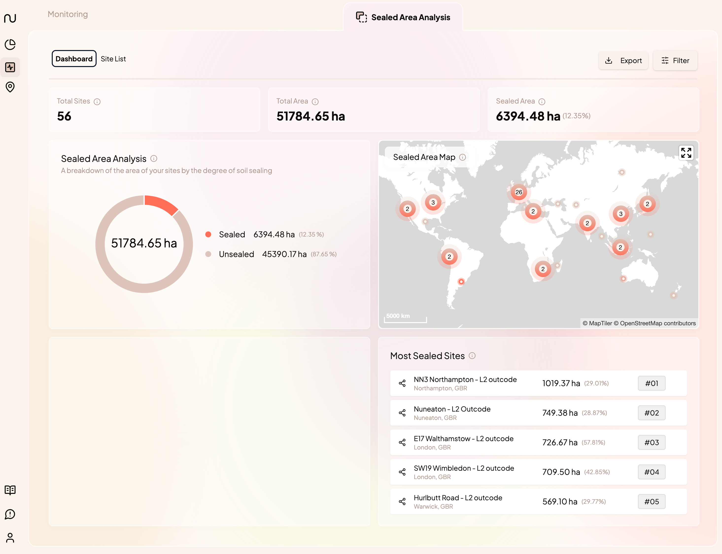
- Key Metrics:
- Total Sites: the total number of sites included in the analysis
- Total Area: the total surface area included in the analysis (in hectares)
- Sealed Area: the total area within the portfolio taken up by sealed soil
- Sealed Area Analysis: a breakdown of the absolute and percentage area in your portfolio taken up by sealed and unsealed soil
- Sealed Area Map: a geographic representation of sealed area in your portfolio. You can use the map to navigate to sites of interest
- Most Sealed Sites: a ranked list of sites with the highest absolute area of sealed soil
Sealed Area Analysis List View
The site list view summarises the sealed area analysis for the sites in the portfolio.
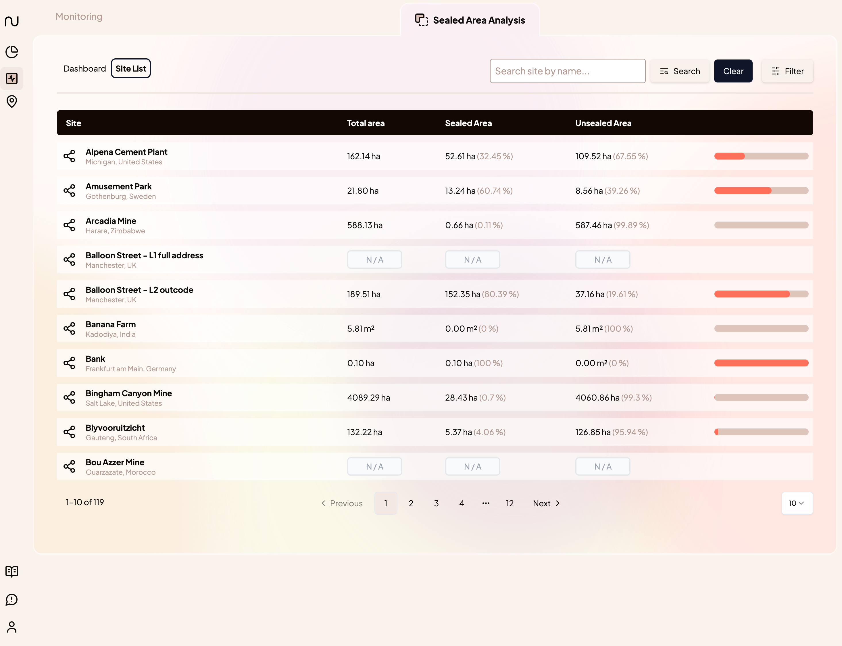
- Total area
- Sealed area (absolute and percentage)
- Unsealed area (absolute and percentage)
- A bar showing the proportion of sealed vs unsealed area
Note: if a site has not been assigned a polygon, it will not be included in the sealed area analysis and will display as “N/A” instead.
Sealed Area Analysis Site View
Clicking on a site will lead you to that site’s sealed area view:
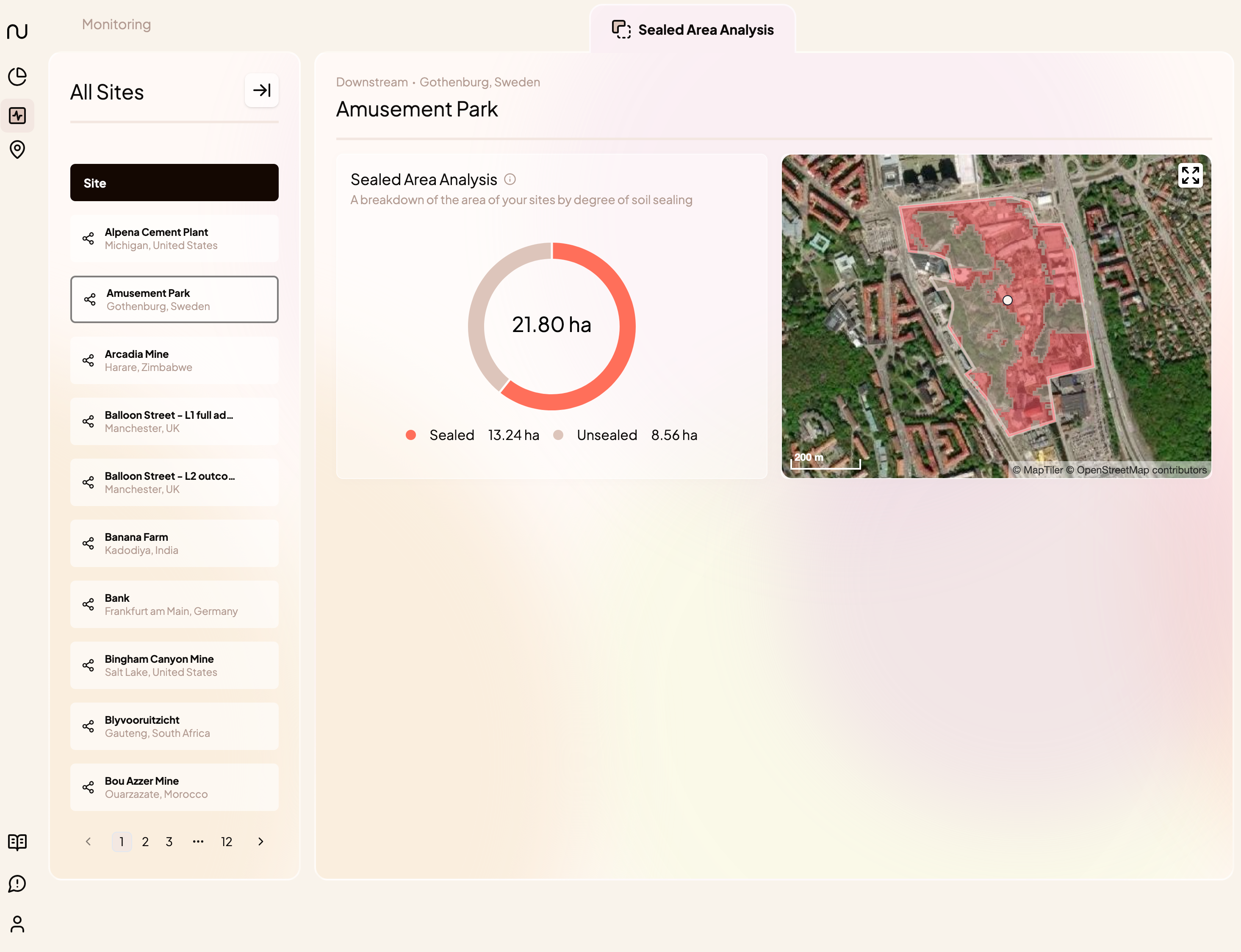
- Sealed Area Analysis: a breakdown of the absolute and percentage sealed and unsealed area for that site
- A map showing the distribution of sealed vs unsealed area at the site.
Sealed Area Analysis Methodology
What is sealed area? Why should I care about it?
Sealed Area refers to land that has been sealed off such that it does not allow water to drain through, e.g. a concrete parking lot. While some areas of the world are naturally sealed (think of bare mountaintops), sealed soil can generally be seen as an indicator of human intervention.
Unsealing areas of sealed soil in your portfolio could have positive impacts on the nature in and around your sites. Understanding the proportion of sealed soil across your assets can help you identify opportunities for taking positive action.
How is sealed area determined? What datasets are used to determine sealed area?
We use Land Use Land Cover (LULC) models to determine the area(s) of your sites that are sealed. LULC models use machine learning to categorise satellite imagery into different land use and land cover classes.
We use the built-up class of a land cover dataset as a proxy for sealed soil, as this gives the most representative indication of areas that have been rendered impermeable.
Which LULC dataset is used to determine sealed area?
We currently use the European Space Agency WorldCover 2021 (ESA WC-2021) dataset to determine sealed soil. We chose this model for its enhanced accuracy in determining built-up areas compared to competing products such as ESRI’s Annual Land Cover or Google Dynamic World.
Sealed Area Indicator Detailed Overview
Summary
Sealed Area provides an overview of the absolute and percentage of a site’s area taken up by sealed soil.
Data Type | High-resolution map based on satellite imagery and AI-powered land classification models |
|---|---|
Source | |
Spatial Resolution | 10m x 10m |
Temporal Resolution | annual average of the year 2021 - not updated |
Interpretation | The site area is screened for sealed area, i.e. surfaces impermeable to water. The indicator enables the visual and quantitative analysis of how much sealed area is found at the site. |
Framework Relevance | Land Cover - Loss of Natural Area is relevant under CSRD (ESRS E4) |
Export | Sealed Area is included in the Export for the Monitoring Module |
Explanation
Sealed area refers to land that has been sealed off such that it does not allow water to drain through, e.g. a concrete parking lot. While some areas of the world are naturally sealed (think of bare mountaintops), sealed soil can generally be seen as an indicator of human intervention.
Unsealing areas of sealed soil in your portfolio could have positive impacts on the nature in and around your sites. Understanding the proportion of sealed soil across your assets can help you identify opportunities for taking positive action.
The sealed area indicator is based on a global 10-metre scale land cover model provided by the European Space Agency called WorldCover 2021 (ESA-WC2021). The model is based on satellite observations from Sentinel-1 and -2, which have been classified into different land use / land cover classes using a deep learning model. We use the model’s ‘built-up’ class as a proxy for sealed soil.
Transformation & Interpretation
The Sealed Area indicator enables you to understand the absolute and percentage area of your portfolio taken up by sealed soil. At the site level, it allows for visual inspection and understanding of sealed soil at a given site for 2021.
Source
Sealed Soil is derived from ESA’s WorldCover 2021 LULC product
Date of publication
2021
Confidence & Accuracy
Medium. ESA WC-2021 is a leading land cover dataset. While the data set features the highest accuracy for classifying built-up area out of comparable data products (especially for small sites), the global accuracy remains only moderate. This is especially relevant when considering small sites (areas <100 sqm), where small errors in classification can lead to large changes in the proportion of sealed area. For more information comparing land cover datasets, see Venter et al. 2022.