
Biodiversity Importance - Critical Habitats
Overview
Data Type | Spatial data on biodiversity-sensitive areas |
|---|---|
Source | |
Spatial Resolution | 1km x 1km |
Temporal Resolution | Regular updates |
Interpretation | Per default, a 5km radius around the site is screened for the occurrence of protected areas. |
Concern Level | Very Low = no BSAs area detected within 5km of the site Low = BSAs area detected within 5km of the site Moderate = BSAs area detected within 3.5km of the site High = BSAs area detected within 1.5km of the site Very High = BSAs area detected within 0.5km of the site |
Framework Relevance | Critical Habitat data is relevant under CSRD (ESRS E4) as well as under TNFD. |
Detailed Specifications
Explanation
The Critical Habitat data provided by UNEP WCMC is based on 12 global datasets (incl. data on key biodiversity areas) to identify areas with high biodiversity conservation significance. The definition of critical habitats is based on the criteria defined in International Finance Corporation (IFC) Performance Standard 6: Biodiversity Conservation and Sustainable Management of Living Natural Resources. An area is a critical habitat if one of the following criteria is fulfilled:
Criteria | Description |
|---|---|
Criteria 1 | Habitat of significant importance to Critically Endangered and/or Endangered species |
Criteria 2 | Habitat of significant importance to endemic and/or restricted-range species |
Criteria 3 | Habitat supporting globally significant concentrations of migratory species and/or congregatory species |
Criteria 4 | Highly threatened and/or unique ecosystems |
Criteria 5 | Areas associated with key evolutionary processes |
Criteria 6 (Scenario A) | Other recognized high biodiversity values that might also support a Critical Habitat designation |
Criteria 7 (Scenario B) | Internationally and/or nationally recognized areas of high biodiversity value that in general will likely qualify as Critical Habitat |
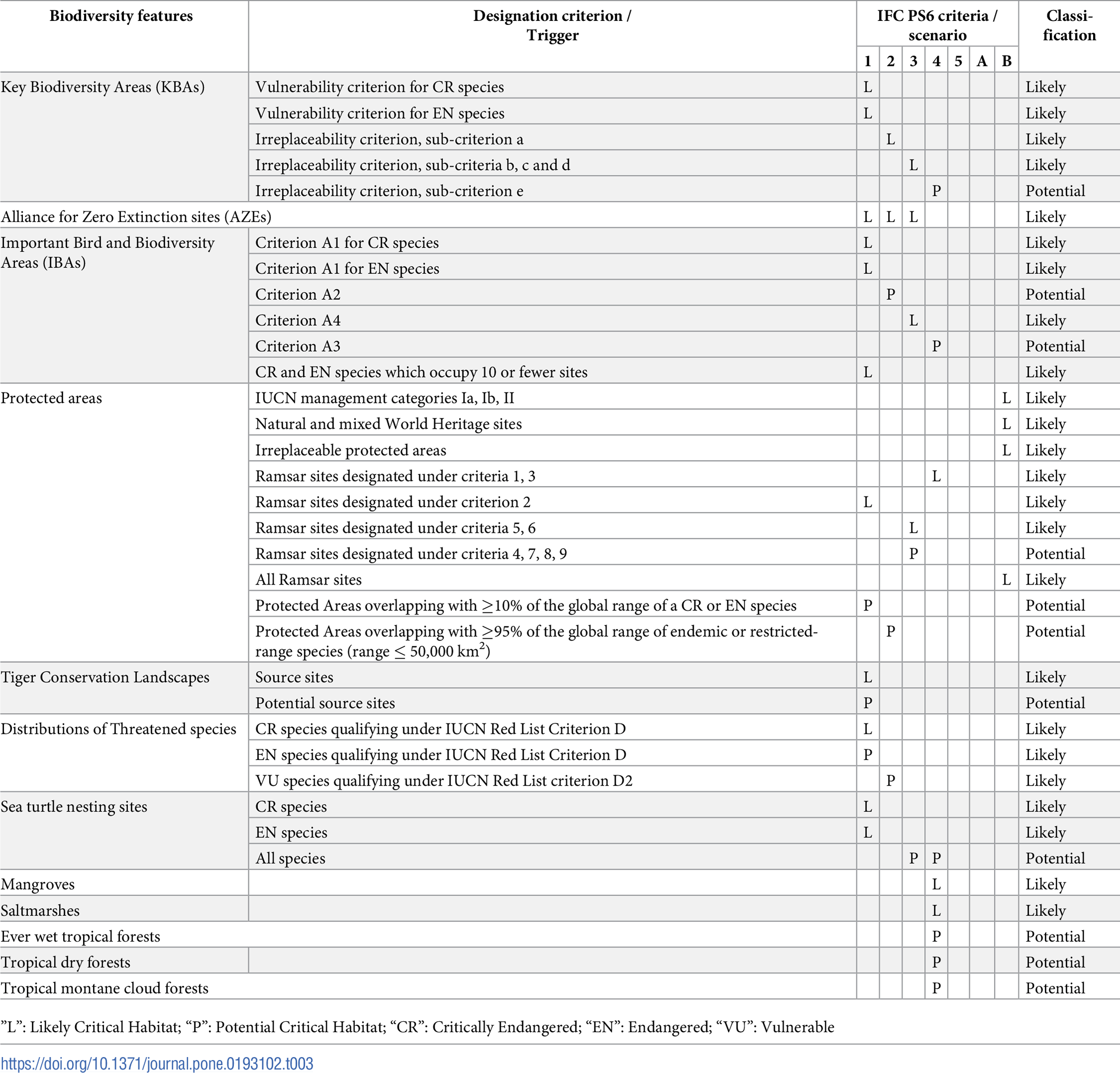
The screening data layer differentiates between potential and likely critical habitats based on the confidence that above criteria are fulfilled. Likely Critical Habitat are determined principally by the occurrence of Key Biodiversity Areas and Protected Areas. Potential Critical Habitat are predominantly characterized by data representing highly threatened and unique ecosystems such as ever-wet tropical forests and tropical dry forests.
- Detailed information on how underlying datasets such as key biodiversity areas are incorporated in the Critical Habitat screening layer can be found in this methodology paper. Below you find a graph that details how underlying datasets are used to Likely and Potential Critical Habitats.
Transformation & Interpretation
A 5km radius around the business site is screened for the overlap with potential or likely critical habitat area. Close proximity to a critical habitat area mean a higher concern level according to the following default logic:
Distance to biodiversity-sensitive area | Concern Level |
|---|---|
> 5 km | Very Low |
3.5 - 5 km | Low |
1.5 - 3.5 km | Moderate |
0.5 - 1.5 km | High |
≤ 0.5 km | Very High |
It is important to note that the Critical Habitat data layer does not provide exact polygons for the underlying protected and designated areas of high biodiversity sensitivity. Instead, it simply indicates the presence of biodiversity-sensitive areas within a 1 km x 1 km grid cell. As a result, the precise boundaries of critical habitats are not defined, introducing an uncertainty of up to 1 km in the proximity analysis.
Additionally to the above proximity analysis and resulting concern level, the following contextual information is provided as part of the indicator:
- The distance between the business site coordinate and the closes 1km x 1km critical habitat area
- Other than for the remaining biodiversity importance datasets, no coverage metric is provided, given the exact boundaries and areas of Critical Habitats are unknown.
Due to data licensing restrictions, the Critical Habitat layer does not include the specific names or types of BSAs. The Critical Habitats Layer integrates data from 12 global datasets (including KBAs) and indicates, for each 1 km² cell, the likelihood that a BSA is present.
Because this is a screening layer, users should verify the presence of a BSA for any sites flagged through Critical Habitats. For non-European sites identified in this way, we recommend consulting online tools such as this one or this one or engaging with local site managers to confirm the BSA’s existence, name and type.
Source
The spatial data on Critical Habitats is provided by UNEP WCMC.
Date of publication
2023
Confidence & Accuracy
Moderate. The Critical Habitat screening layer is based on the best available global-scale data sets on biodiversity sensitive areas that are available for commercial use. However, the aggregated nature of the data (1km x 1km) means that the exact boundaries of critical habitats and the names of the underlying protected sites are not known.
Relevance for CSRD
CSRD requires companies to identify operational sites located in or near biodiversity-sensitive areas that negatively affecting these areas.
Biodiversity-sensitive areas (BSA) are defined as:
- Natura 2000 network of protected areas
- UNESCO World Heritage sites
- Key Biodiversity Areas (‘KBAs’)
- other protected areas
The Critical Habitat dataset is based on 20 global datasets identifying biodiversity-sensitive data (incl. data on key biodiversity areas). Biodiversity-sensitive areas are relevant under:
ESRS Article | Disclosure or application requirement |
|---|---|
ESRS E4 DR 16 (a) (i) | list of material sites in its own operations specifying activities negatively affecting biodiversity sensitive areas |
ESRS E4 DR 16 (a) (iii) | specifying the biodiversity-sensitive areas impacted |
ESRS E4 DR 19 (a) | sites located in or near biodiversity-sensitive areas and activities related to these sites negatively affect these areas |
ESRS E4 DR 35 (a) | number and area (in hectares) of sites located in or near biodiversity-sensitive areas that negatively affect area |
ESRS E4 AR 7 (d) | list of locations where the undertaking is interfacing with biodiversity-sensitive areas |
ESRS E4 AR 8 (c) (i) | percentage of its suppliers’ facilities located in risk prone areas |
ESRS E4 AR 8 (c) (ii) | percentage of procurement spend from suppliers with facilities located in risk prone areas |
CSRD requires companies to consider and describe the data used in their analysis (ESRS E4 AR 27). For convenience, here a description of for the relevant criteria:
ESRS Data Criteria | Comment |
|---|---|
(a) methodology, | Methodology: The Critical Habitat data provided by UNEP WCMC is based on 12 global datasets (incl. data on key biodiversity areas) to identify areas with high biodiversity conservation significance. The definition of critical habitats is based on the criteria defined in International Finance Corporation (IFC) Performance Standard 6: Biodiversity Conservation and Sustainable Management of Living Natural Resources. Reason for selection: The indicator has been selected to provide information on the proximity of sites to biodiversity-sensitive areas. The Critical Habitat data includes data explicitly listed as biodiversity-sensitive area under ESRE E4. Limitations & uncertainties: The Critical Habitat screening layer is based on the best available global-scale data sets on biodiversity sensitive areas that is available for commercial use. However, the aggregated nature of the data (1km x 1km) means that the exact boundaries of critical habitats and the names of the underlying protected sites are not known. |
(b) scope of metric | The Critical Habitat data is applied at site level applying a 5km radius. |
(c) biodiversity component of metric | The Critical Habitat does not directly relate to a biodiversity component. However, with the objective of identifying habitats important to threatened species and ecosystems, the Critical Habitat data indirectly relates to both species extinction risk and ecosystem extent and condition. |
(d) covered geographies | The Critical Habitat data is global. |
(e) integration of ecological thresholds | The Critical Habitat data does not relate to a specific planetary boundary. |
(f) frequency of monitoring, baseline condition and period | Critical Habitat data is updated regularly. |
(g) data type (primary, secondary, modelled, expert judgement | Critical Habitat data can be considered secondary data. |
Relevance for TNFD
Proximity to Critical Habitats is a suitable indicator to estimate the criteria Biodiversity Importance within TNFD’s LOCATE step.
Relevance for SBTN
Proximity to Critical Habitats are not directly relevant as a State of Nature indicator for Step 1: Assess and Step 2: Interpret & Prioritize. Nevertheless, the proximity of UNESCO WHS provides additional qualitative information on an areas biodiversity importance and integrity which can complement other biodiversity State of Nature indicators.
| SBTN Data & Tool Criteria | Evaluation | Comment |
|---|---|---|
Relevance | ❌ | Proximity to Critical Habitats is not directly relevant to SBTN methodology for State of Nature Assessments. |
Representative | ❌ | Proximity to Critical Habitats is not directly applicable to SBTN’s quantification of the State of Nature Assessments. |
Spatial and Temporal Resolution | ✅ | The Critical Habitat screening layer is based on the best available global-scale data sets on biodiversity sensitive areas that is available for commercial use. However, the aggregated nature of the data (1km x 1km) means that the exact boundaries of critical habitats and the names of the underlying protected sites are not known. The data is updated regularly. |
Stability and Preservation | ✅ | Critical Habitat data is likely to be maintained and preserved long-term as is is provided by UNEP WCMC. |
Accessibility | ✅ | Critical Habitat data is readily accessible online. |
Interpretability | ✅ | Critical Habitat data is sufficiently interpretable. |
Coverage | ✅ | Critical Habitat data has global coverage. |
Authoritative and Accurate | ✅ | Critical Habitat spatial data is provided and updated by the UNEP WCMC implying high accuracy of the data. |